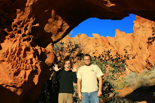
VALLEY OF FIRE STATE PARK
 Disclaimer: Sorry about the photo quality, I was messing with my settings on my camera a couple weeks ago and never reset them!


 Marie holding Emma (above)
Cory taking a typical Cory shot! At least this time he wasnt lying down in the middle of the road. Fortunetely he has not yet been struck by a speeding car.
 One of the most impressive vistas was the Fire Canyon Overlook. It was amazing how the red and white color change was so abrupt.

Marjory Kay really wanted to go on a hike so we hike the White Dome loop. This was a fun/easy trail that had a little bit of fun for everyone. There was scrambling, slot canyons and arches to explore and photograph all in a 1 1/2 mile hike.


 One of my favorite parts of VOFSP is rock art record left by ancient inhabitants. Even in such a desolate, out of the way place, ancient civilizations found the place to be sacred as proven by the record of petroglyphs. The first picture is of the famous atlatl rock. I have a better pic of the atlatl that I will find later, but if you look at the very top you can barely see the atlatl.
Perhaps the most fun hike that the Reese children did was the hike to Mouses Tank. Mouse was a renegade Paiute who plagued the early settlers. He would hide in this canyon when the early white settlers searched for him. The reason the kids liked the canyon so much was the amount of lizards they found and unsuccessfully attempted to catch. I think Jackson counted over 20. I enjoyed the hike because in half a mile hundreds of rock art was easily found. My favorite one was a panel that included a desert tortoise.

Even pregnant, Renee is still HOT!!


A petroglyph of a desert tortoise (below, middle of picture)


 I have been desirious to look at the petroglyphs located above the Santa Clara river for several months, but either due to weather, or lack of time I have not been able to go. Saturday I decided I would find them. As my wife and I drove towards St. George to run errands, I asked if she cared if we went on a little adventure. Luckily for me I am married to someone who understands me! She told me I had an hour, I would like to remind any reader she is over 6 months pregnant and hiking is not high on her list of things to do right now. As we hiked along there were several indicaters of rock art left by the Anasazi who lived in the area, and we found several panels on the top of the rocks. These petroglyphs are a little strange compared to the others I have seen. Traditionally they are carved on a verticle rock, most of these ones were carved on the top of horizontal rocks. After an hour my time was up and we decided it was time to turn around. As we began hiking back the same route, I heard voices coming below us. The voices were stationary so I assumed they must be looking at something. We hiked toward the voices and found the best panels of the entire hike. One shaman figure on one rock, and on another rock two very large goats with what appears to possibly be a mountain lion following them. Finally after my hour was well up, I thanked my beautiful wife for coming with me. I told her that finding these sites is like a pirate finding his treasure.


 Over the summer I went on what basically amounted to a field trip for teachers. It was a memorable trip, but one with several missed opportunities. One of these opportunities was Monument Valley. We drove to within view of the monoliths but that was it. After the trip I decided to return someday. The ole wife, cory (bro-in-law) Jackson (nephew), Trevor(bro) and made the trip, this time to actually explore Monument Valley. The trip was a quick two dayer and we covered a lot of ground. We were up by sunrise and didnt put our heads down till well after sunset.
  Our first stop was the Betatakin ruins of Navajo National Monument. Unfortunately for us the rangers werent willing to hike with us down to the ruins and without the guides you are not allowed down to them. Fortunately for us they wouldnt go because it would have been a long cold, hike into the snow filled valley! In fact just hiking to the overlook young Jackson slipped on ice and threw a fit that could have awoken a hibernating grizzly. NNM is surely a place I will return to.


 Day 2 of our trip we decided to head further south, and made our way to the South Rim of the Grand Canyon. Being at over 7000 ft it was frigid but at the same time was exhilarating. The air was clean and crisp and visibility was amazing. In fact we were able to see the Arizona Strips Mount Trumball from the South Rim. I would recommend a trip to the South Rim for everyone living in the southwestern United States. It is only a 4-5 hour drive from Southern Utah. I know the North Rim is much closer but going to the South Rim is a completely different experience from that of the North Rim.
 SUNRISE ON THE SOUTH RIM


 Hoping to get our blood pumping and warm up we decided to hike to two arches, a window and magnificent alcove above the wave. Thanks to the directions from Tonya and Bo's website "http://www.zionnational-park.com/coyote-buttes-paria.htm" we scrambled to the top of the slickrock mountain and found top rock arch, melody arch and window, and the alcove. Even though they are not extremely difficult to find it is still exhilarating when after hiking around semi turned around we found such places. The feeling must be somewhat comparible to finding a buried treasure!